Xinjiang Location Map: Where is Xinjiang Located on a Map

This map shows the position of Xinjiang Uyghur Autonomous Region in the far northwest of China. It is the largest provincial-level region in China and lies much farther west than the country's major coastal cities.
On the map, you can see that Xinjiang is closer to Central Asia than to eastern China. Its capital, Urumqi, is about 3,000 km (1,860 miles) from Beijing, with direct flights taking around 4–4.5 hours.
Xinjiang borders several countries in Central Asia and South Asia, including Kazakhstan, Kyrgyzstan, Tajikistan, Pakistan, and Mongolia. Because of this location, the region has long been an important crossroads along the ancient Silk Road connecting China with Central Asia and beyond.
Xinjiang Map with Cities: Distance & Connections
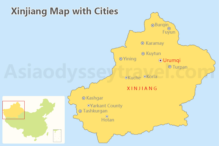
This map highlights the major cities across Xinjiang, showing where the region's main travel hubs and destinations are located. Because Xinjiang is extremely large, journeys between cities can be long, and most travelers move between them by domestic flights or long-distance drive.
On the map, you'll notice that Urumqi sits in the north and serves as the main transportation hub, with the region's largest airport and railway connections. From here, travelers typically explore other famous destinations such as Kashgar, Turpan, and the scenic Ili Valley around Yining.
The table below lists some of the major travel cities in Xinjiang, their distance from Urumqi, and whether they have an airport.
| City / Destination | Key Highlights | Distance from Urumqi | Airport |
|---|---|---|---|
| Turpan | Flaming Mountains, grape valleys, ancient Silk Road ruins | ~180 km | Yes (TLQ) |
| Karamay | Oil city, famous for the Yardang “Ghost City” landforms | ~310 km | Yes (KRY) |
| Korla | Gateway to the Tarim Basin and desert landscapes | ~470 km | Yes (KRL) |
| Altay | Access point to the Altai Mountains and Kanas region | ~660 km | Yes (AAT) |
| Yining | Ili River Valley, grasslands, and Kazakh culture | ~700 km | Yes (YIN) |
| Kucha | Ancient Silk Road oasis, Kizil Thousand Buddha Caves | ~740 km | Yes (KCA) |
| Kashgar | Old Town, Sunday Bazaar, strong Uyghur culture | ~1,470 km | Yes (KHG) |
| Hotan | Jade culture, desert oasis, Silk Road heritage | ~1,530 km | Yes (HTN) |
| Tashkurgan | Pamir Plateau scenery and gateway to the Karakoram Highway | ~1,950 km | Yes (HQL) |
- Xinjiang is extremely large. Distances between destinations are often hundreds or even over a thousand kilometers, so travelers usually combine flights, trains, and long scenic drives when exploring the region.
- High Frequency on Key Routes: Major tourist corridors like Urumqi ⇄ Kashgar, Urumqi ⇄ Ili (Yining), and Urumqi ⇄ Altay operate like "air bridges." In peak tourist seasons (June–October) and during holidays, these routes often have 10–20+ flights per day combined across different airlines.
Xinjiang Tourist Map: Xinjiang Map with Top Attractions
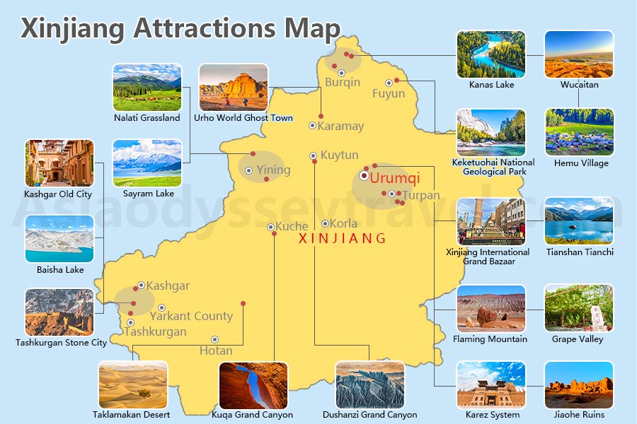
This large map gives you a complete view of Xinjiang's top attractions, with each destination marked and highlighted by small image frames for a quick visual reference.
It's perfect for first-time travelers who want to get a sense of the region's diversity at a glance.
Think of it as your Xinjiang tourist map, showing where lakes, deserts, mountains, and cultural treasures are located—so you can easily plan your route before even setting foot in the region.
Northern Xinjiang Map - Nature Beauty on the Map

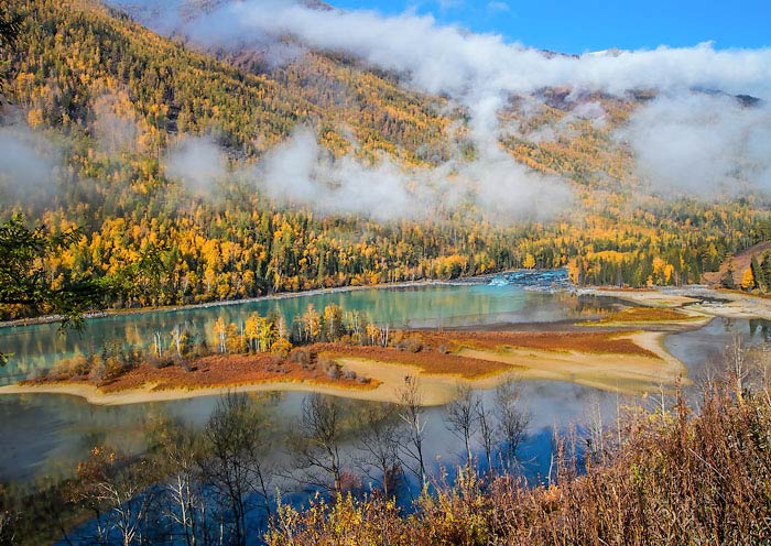
Northern Xinjiang, framed by the Tian Shan Mountains, is a paradise of natural scenery. This map highlights lakes, grasslands, alpine forests, canyons, and colorful desert formations, offering breathtaking landscapes that resemble Kyrgyzstan in feel.
You can explore crystal-clear alpine lakes like Kanas and Tianchi, wander through the rolling Nalati Grasslands, and admire unique geological formations like the Urho Ghost Town and Five-Colored Beach.
The map marks each site clearly, showing relative locations and how to reach them, making it easy to combine multiple stops into a nature-focused itinerary. It's ideal for hiking, photography, and experiencing Xinjiang's vast and wild scenery.
The table below shows what you can find on the northern Xinjiang Map:
| Attraction | Type / Highlight | Near Which City |
|---|---|---|
| Kanas Lake | Alpine lake, forests, spectacular scenery | Burqin / Altay |
| Hemu Village | Traditional wooden village, autumn scenery | Burqin |
| Heavenly Lake | Famous alpine lake in the Tian Shan Mountains | Urumqi |
| Urho Ghost City | Dramatic wind-eroded desert formations | Karamay |
| Keketuohai National Geological Park | Canyon landscapes and geology park | Fuyun |
| Five‑Colored Beach | Colorful sandstone formations by the Irtysh River | Burqin |
| Sayram Lake | High-altitude "Atlantic's last teardrop" lake | Bole |
| Nalati Grassland | Vast grassland, Kazakh nomadic culture | Yining |
| Xinjiang International Grand Bazaar | Cultural bazaar, Uyghur food and shopping | Urumqi |
| Dushanzi Grand Canyon | Dramatic canyon landscapes | Kuitun |
Southern Xinjiang Map - History & Culture

Southern Xinjiang, located below the Tian Shan, is rich in history, culture, and ethnic diversity. This map highlights Silk Road cities, ancient ruins, deserts, oasis towns, and Uyghur cultural sites.
Also, you can find the largest desert of China - Taklamakan Desert - in the centre of Southern Xinjiang, with cities and towns surround it.
You can trace the history of the Silk Road through Kashgar Old City, the Kuqa Grand Canyon, and Tashkurgan Stone City, or enjoy the natural charm of the Taklamakan Desert and serene Baisha Lake.
The table below shows what you can find on the southern Xinjiang Map:
| Attraction | Type / Highlight | Near Which City |
|---|---|---|
| Taklamakan Desert | One of the world's largest shifting sand deserts | Korla / Hotan |
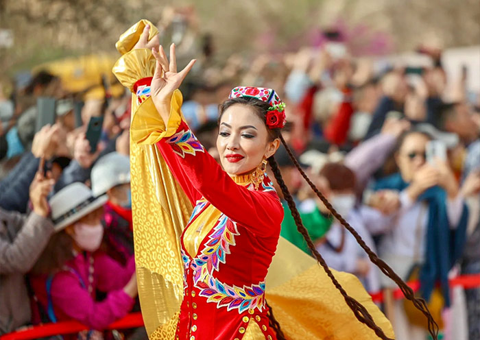
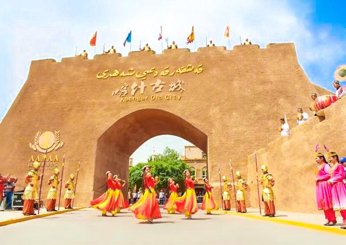
| Kashgar Old City | Traditional Uyghur architecture and culture | Kashgar |
| Kuqa Grand Canyon | Red sandstone canyon landscapes | Kuqa |
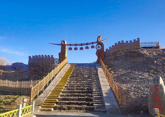
| Tashkurgan Stone City | Ancient Silk Road ruins on the Pamir Plateau | Tashkurgan |
| Baisha Lake | Turquoise lake with white sand dunes | Tashkurgan |
| Flaming Mountains | Red desert mountains from Journey to the West | Turpan |
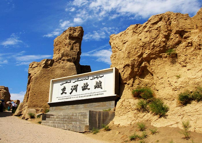
| Jiaohe Ancient City | Well-preserved Silk Road ruins | Turpan |
| Karez Irrigation System | Underground irrigation engineering | Turpan |
| Grape Valley | Vineyards and oasis culture | Turpan |
Xinjiang Railway Map - High Speed Rails & Conventional Rails
Xinjiang is vast and large. It occupies roughly one-sixth of China's total land area—making it larger than many European nations combined (surpassing the size of France, Germany, Spain, and Italy put together).
Because distances between cities are so great, railways play an important role in regional travel, linking major destinations across deserts, mountains, and oasis cities.

This Xinjiang Railway Map highlights the region's main rail corridors, including several high-speed rail lines centered on Urumqi as well as long-distance conventional railways reaching deep into southern and northern Xinjiang.
The map helps travelers quickly see how key cities—such as Turpan, Korla, Yining, Altay, Kashgar, and Hotan—are connected by train.
The table below summarizes the main routes shown on the Xinjiang railway map, including train types and approximate travel times.
| Route | Train Style | Train Travel Time |
|---|---|---|
| Urumqi - Turpan | High Speed Train ( D Train) | 1 h |
| Urumqi - Hami | High Speed Train ( D Train) | 2.5-3 h |
| Urumqi - Korla | High Speed Train ( C Train) | 3.5-4 h |
| Urumqi - Yining (Ili) | High Speed Train ( C Train) | 5-6 h |
| Urumqi - Altay | Conventional Rail (K Train) | 7.5-13.5 h |
| Urumqi - Kashgar | Conventional Rail (Z/T/K Train) | 11.5 - 18 h |
| Korla - Kashkar | Conventional Rail (T/K Train) | 10 - 13 h |
| Kashkar - Hotan | Conventional Rail (K Train) | 5-6 h |
| Hotan - Ruoqiang | Conventional Rail (K Train) | 9.5 - 11.5 h |
| Ruoqiang - Korla | Conventional Rail (K Train) | 4-7 h |
Notes:
- Most travelers first fly to Urumqi, the main gateway to Xinjiang Uyghur Autonomous Region. From there, they usually continue by private car, domestic flight, or train to other destinations.
- The most popular rail route into Xinjiang is the high-speed train from Lanzhou to Urumqi, which connects famous Silk Road cities such as Xining, Zhangye, Jiayuguan, Dunhuang, and Turpan.
Xinjiang Travel Map & Travel in Xinjiang with Map
Northern Xinjiang Travel Map
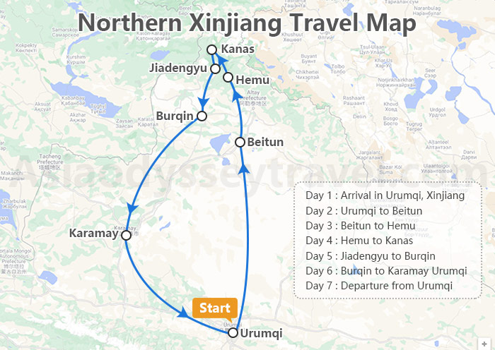
Day 1: Arrival in Urumqi, Xinjiang: Arrive in Urumqi, Xinjiang, where you will be greeted with airport pickup services and assisted with check-in procedures at your hotel for a comfortable stay.
Day 2: Urumqi to Beitun: Explore the stunning Heavenly Lake in the Tianshan Mountains and enjoy the breathtaking landscapes of the Bogda Mountains in Beitun.
Day 3: Beitun to Hemu: Visit the picturesque village of Hemu, interact with the local Tuva community, and witness the beauty of the sunset over the landscape.
Day 4: Hemu to Kanas: Experience the sunrise in Hemu Village, explore the mystical Kanas Lake, and visit the Three Bays area before heading to Jiadengyu.
Day 5: Jiadengyu to Burqin: Witness the unique beauty of the Five-Colored Beach in Burqin before departing from Urumqi.
Day 6: Burqin to Karamay Urumqi: Explore the eerie landscape of the Ghost City in Wuerhe near Karamay before returning to Urumqi.
Day 7: Departure from Urumqi: Check out from your hotel in Urumqi and receive assistance with transfer to the airport for your departure, concluding your memorable journey through Xinjiang.
7 Days Northern Xinjiang Essential Tour: from Heavenly Lake to Kanas Lake
Urumqi - Beitun - Hemu - Kanas Lake - Burqin - Karamay - Urumqi
Southern Xinjiang Travel Map
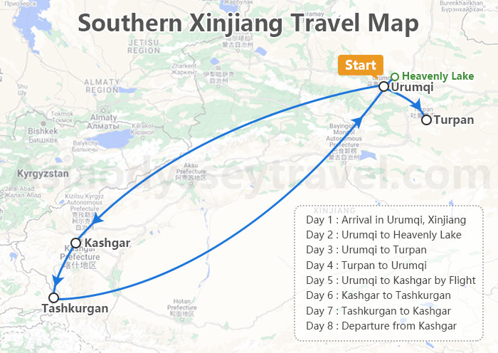
Day 1: Arrival in Urumqi: Arrive in Urumqi where you will be met at the airport for transfer to your accommodation. Complete check-in procedures and relax after your journey.
Day 2: Urumqi to Heavenly Lake: Visit the picturesque Heavenly Lake in the Tianshan Mountains, followed by a trip to the Xinjiang Regional Museum to immerse yourself in the history and culture of the region.
Day 3: Urumqi to Turpan: Journey to Turpan, passing by the iconic Flaming Mountains. Explore the charming village of Tuyugou and marvel at the ancient Bezeklik Thousand Buddha Caves.
Day 4: Turpan to Urumqi: Discover the ancient ruins of Jiaohe at the Jiaohe Ancient City site. Explore the remarkable Karez Water System and admire the architectural beauty of the Emin Minaret before returning to Urumqi.
Day 5: Urumqi to Kashgar by Flight: Fly to Kashgar and delve into the historic Kashgar Old City, visiting landmarks like the Id Kah Mosque and ancient tea houses. Explore the Livestock Market if it falls on a Sunday.
Day 6: Kashgar to Tashkurgan: Travel along the breathtaking Karakoram Highway, passing through the Pamir Plateau. Stop by scenic spots like White Sand Lake and Karakul Lake, and experience the hospitality of a Tajik family.
Day 7: Tashkurgan to Kashgar: Explore the ancient Stone City of Tashkurgan and enjoy the vastness of the Alar grasslands before returning to Kashgar.
Day 8: Departure from Kashgar: Check out from your hotel in Kashgar and transfer to the airport for your onward journey, bidding farewell to the enchanting city of Kashgar.
8 Days Xinjiang Culture & Nature Tour: Urumqi Tianchi Turpan Kashgar Tashkurgan
Urumqi - Tianchi Lake - Urumqi - Turpan - Kashgar - Tashkurgan - Kashgar