Ngari Location Map: Where Is Ngari Located on Map?
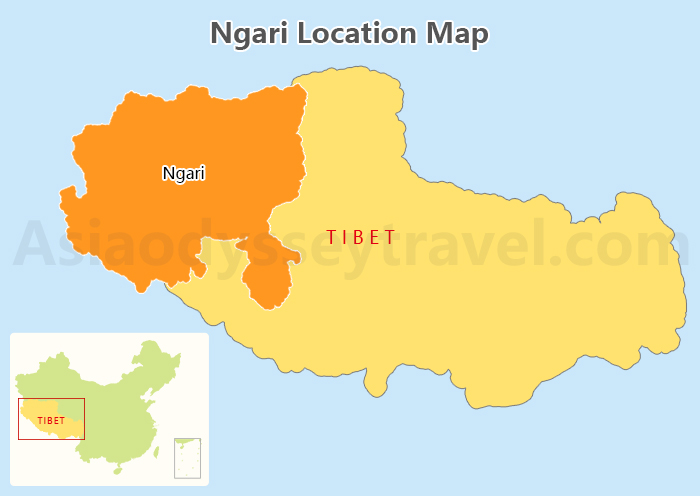
Ngari lies in the western part of Tibet Autonomous Region, bordering several regions and countries.
To the east, it connects with Nagqu and Shigatse. To the north, it borders the Xinjiang Uygur Autonomous Region. Its southwestern and western boundaries meet Nepal and India.
Ngari Tourist Map: Top 8 Ngari Attractions on Map
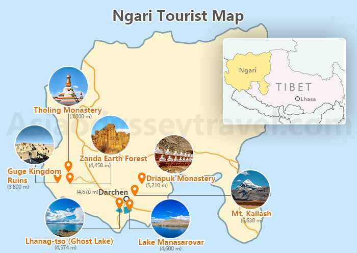
Ngari is not only a treasure trove of natural beauty, but also one of the most important birthplaces of Tibetan culture. Check out Ngari's top attractions on the map.
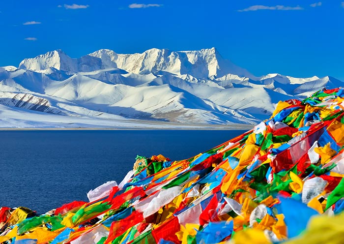
- Kailash (冈仁波齐峰) - 6,638m
Standing 6,638 meters tall, this sacred mountain is revered by Tibetan Buddhism, Hinduism, Bon, and Jainism as the center of the world. Each year, countless pilgrims perform the ritual circumambulation, a deeply spiritual experience.
- Lake Manasarovar (玛旁雍措) - 4,600m
Dubbed the "Sacred Lake at the Center of the World," its crystal-clear waters, surrounded by snow-capped mountains, offer breathtaking views. This holy site also attracts photographers seeking perfect shots of its serene beauty.
- Lhanag-tso (拉昂措) - 4,574m
Separated from Lake Manasarovar by a narrow isthmus, this mysterious saltwater lake is known as Tibet Ghost Lake and features deep blue waters and a distinct charm, making it a unique sight in Ngari.
- Guge Kingdom Ruins (古格王国遗址) - 3,800m
Located in Zanda County, this ancient city from the 10th to 17th centuries is famed for its grand architecture and exquisite murals. Spread over 180,000 square meters, the site houses over 600 structures, forming a magnificent archaeological wonder.
- Zanda Earth Forest (札达士林) - 4,450m
This natural wonder, carved by wind and rain, spans more than 240 square kilometers. Its unique soil formations create an otherworldly landscape, perfect for exploration and photography.
- Tholing Monastery (托林寺) - 3,800m
With over a thousand years of history, this monastery blends Indian, Nepalese, and Tibetan architectural styles. Its collection of ancient murals and statues offers invaluable insight into Tibetan Buddhism's artistic heritage.
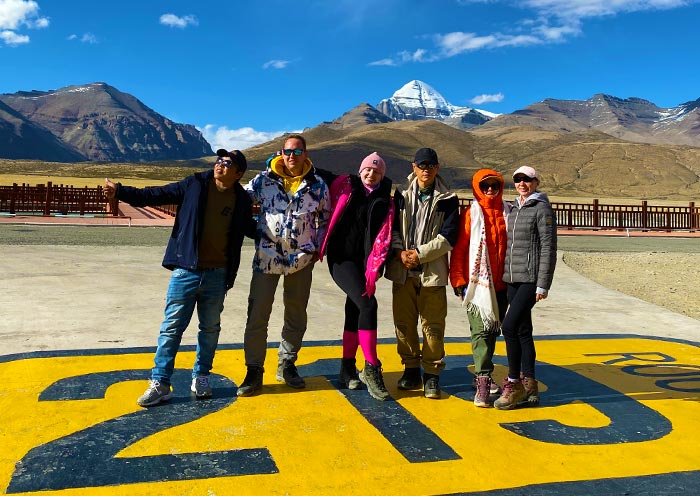
- Darchen (塔钦) - 4,670m
Located at the foot of Mt. Kailash, this small but well-equipped town serves as the starting and finishing point for pilgrims and trekkers undertaking the sacred kora.
- Dirapuk Monastery (止热寺) - 5,210m
Known for its artistic and cultural significance, the monastery features over 300 Buddha statues and 500 murals. It stands as an essential site for understanding Tibetan Buddhist heritage.
Ngari Transportation Map: How to Get to Ngari?
Air travel is the fastest way to reach Ngari, though flights are limited and subject to weather conditions.
Many travelers get to and around Ngari, Tibet by car. The Xinjiang-Tibet Highway (National Highway 219) serves as a critical lifeline connecting Ngari to other regions.
If driving, proper preparation is essential, including vehicle checks, stocking spare supplies, mastering high-altitude driving techniques, and familiarizing yourself with fuel stations. It is advisable for experienced drivers to undertake this journey and prioritize safety at all times!
Lhasa to Ngari

Distance: About 1,200 km
By Plane: A 5-hour flight from Lhasa Gonggar Airport to Ngari Kunsha Airport, followed by a 1-hour drive, takes about 3.5-4 hours in total.
By Car: The journey via National Highway 318 and 219 takes 2-3 days, offering stunning views of the Himalayas and Gangdise Mountains. For a more relaxed experience, combine driving with sightseeing, extending the trip to 3-4 days.
Xinjiang to Ngari

Distance: About 1,300 km from Kashgar, Xinjiang
By Plane: Direct flights from Kashgar to Ngari take approximately 5 hours.
By Car: Driving via National Highway 315 and 219 across the Pamir Plateau and Taklamakan Desert takes about 3-4 days, depending on the route and road conditions. Service areas along the way ensure a convenient journey.
Nepal to Ngari of Tibet, China
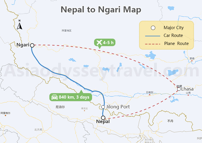
Distance: About 840 km from Kathmandu
By Plane: Daily flights from Kathmandu to Lhasa are available. Fly from Kathmandu to Lhasa and transfer to a flight to Ngari Kunsha Airport, totaling 4-5 hours, plus a 2-hour drive.
By Road: To travel overland from Nepal to Ngari, take a bus or car from Kathmandu to the Gyirong Port (Jilong Port) border, and then drive to Ngari. Takes 3 days or so.
Travel Permits Required to Visit Ngari, Tibet
To visit Ngari in Tibet, international travelers need the following travel permits in addition to a Chinese visa:
- Tibet Travel Permit – Required for entry into Tibet (Xizang) and travel within the Lhasa area.
- Aliens’ Travel Permit – Necessary for visiting regions outside Lhasa.
- Military Travel Permit – Required for travel to military-sensitive areas, including Ngari, Shannan, Chamdo, and Nyingchi.
- Frontier Pass – Mandatory for travel near China's borders with Nepal and Bhutan, covering destinations like Mount Everest and Mount Kailash.
All permits must be arranged before your trip and are typically handled by the tour operator like Asia Odyssey Travel (AOT). For more details, check our Tibet Travel Permit Page >>
Ngari Map with Airports
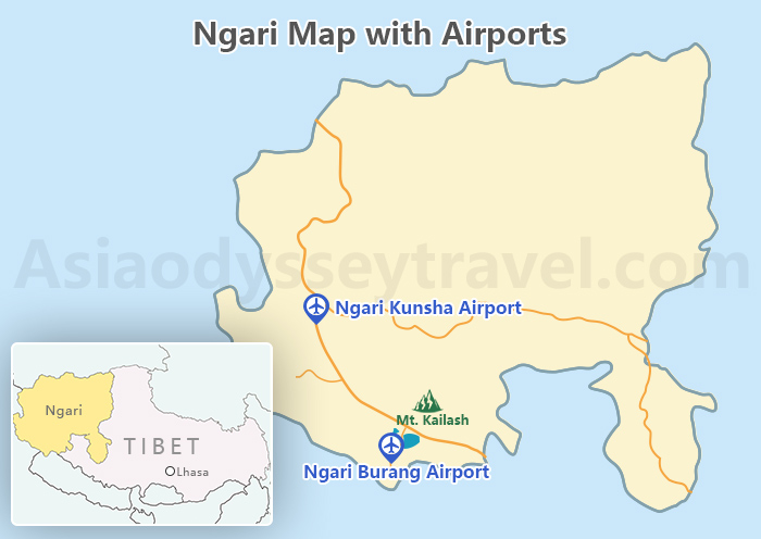
Despite its remote location and rugged terrain, Ngari is accessible via two high-altitude airports. However, the region lacks a railway network for now, although improvements in connectivity are anticipated in the future.
- Ngari Kunsha Airport (阿里昆莎机场)
Location: 45 km southwest of Shiquanhe Town in Kunsha Township
Altitude: 4,274 meters, the third-highest airport in the world
How to Get to Shiquanhe Town: About 1-hour drive
- Ngari Burang Airport (阿里普兰机场)
Location: Ren'gong Village, Burang County, 12 km south of Burang Town
Altitude: 4,250 meters, classified as a high plateau airport
How to Get to Shiquanhe Town: About 4-5 hour drive
Ngari Travel Map: Tour Ngari with Map
Most travelers combine a visit to Ngari with a panoramic exploration of Tibet. Here’s how to spend your time in Ngari and other key destinations in Tibet (Xizang). See the best Tibet attractions on a Tibet Map >>
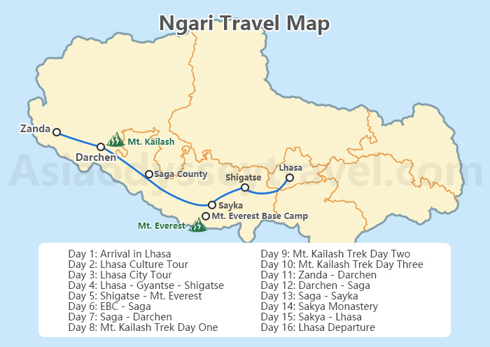
Suggested Itinerary for a Tibet Journey with Ngari Mount Kailash
This classic 16-day Tibet Ngari tour begins with a city tour of Lhasa, continues to Shigatse and Mt. Everest Base Camp, includes a 3-day trek around Mt. Kailash, and delves into the mysteries of the Guge Kingdom.
Check out the Ngari Travel Map for a detailed day-by-day itinerary to immerse yourself in the wonders of Western Tibet.
Day 1: Arrival in Lhasa | Airport Pick-up and Hotel Check-in
Day 2: Lhasa Culture Tour | Lhasa Traditional Handicraft Art Center, Sera Monastery
Day 3: Lhasa City Tour | Potala Palace, Jokhang Temple, Barkhor Street, Tibetan-style Featured Dinner
Day 4: Lhasa - Gyantse - Shigatse | Yamdrok Lake, Karola Glacier, Gyantse Kumbum
Day 5: Shigatse - Mt. Everest | Gyawu La Pass, Rongbuk Monastery, Mt. Everest Base Camp, EBC Hot Pot Dinner
Day 6: EBC - Saga | Mount Shishapangma, Pelkhu-tso
Day 7: Saga - Drongpa County - Darchen | Lake Manasarovar, Lhanag-tso
Day 8: Mt. Kailash Trek Day One: Darchen - Driapuk Monastery
Day 9: Mt. Kailash Trek Day Two: Driapuk Monastery - Dzultripuk
Day 10: Mt. Kailash Trek Day Three: Dzultripuk - Darchen - Zanda
Day 11: Zanda - Guge Kingdom - Earth Forest - Tholing Monastery - Darchen
Day 12: Darchen - Saga
Day 13: Saga - Sayka
Day 14: Sayka - Sakya Monastery - Sakya
Day 15: Sakya - Shigatse - Tashilhunpo Monastery - Lhasa (By Tourist Bus or Train)
Day 16: Lhasa Departure | Hotel Check-out and Airport Transfer
Travel with Asia Odyssey Travel (AOT) to Explore Ngari, Tibet
Taking a journey to Ngari, Tibet is an adventure of a lifetime, and Asia Odyssey Travel (AOT) is your trusted partner for an amazing experience!
With in-depth expertise and personalized services, we ensure that every aspect of your trip is seamlessly planned. By leveraging the insights from the Ngari map, we provide access to iconic sites such as Mt. Kailash, Lake Manasarovar, and the Guge Kingdom.
Choose AOT to unlock the mysteries of Ngari and immerse yourself in the cultural and natural wonders of Tibet like never before.