Mount Kailash Location Map
Check the Location of Kailash Mountain map:
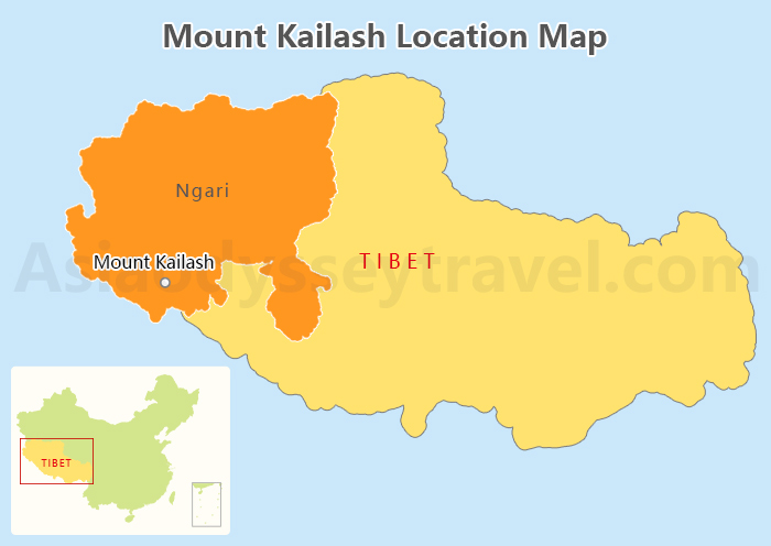
Mount Kailash is located in the Ali region of western Tibet (Xizang), China. As the main peak of the Gangdise Mountains, it stands at an altitude of 6,656 meters, north of the Himalayas. Revered as the center of the world by four major religions - Buddhism, Bon, Hinduism, and Jainism - it is truly a sacred mountain.
Geographically, Mount Kailash is situated on a vast plateau, surrounded by magnificent natural landscapes including Lake Manasarovar, Tholing Monastery, and the ancient Guge Kingdom. It is located less than 100 kilometers from the tri-junction of China, India, and Nepal, 1200 kilometers east of Lhasa, the capital of Xizang, and 753 kilometers from Mount Everest in the Shigatse region.
Mount Kailash Kora Map: 3 Days Trekking
To help you visualize the various checkpoints of the Mount Kailash Trekking, please refer to the Kailash Kora map.
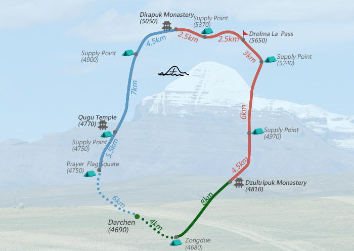
To explore the beauty of Mount Kailash, many travelers choose the Kora trek, a 52-kilometer pilgrimage route around the sacred mountain. Starting and ending in Darchen, the trek offers stunning views of the mountains and surrounding landscapes. Typically taking three days to complete, this hike allows you to walk alongside devout pilgrims and experience one of the world's most sacred treks.
Three-Day Clockwise Hiking Itinerary:
Day 1: Darchen - Dirapuk Monastery (6 h, 22 km)
-
Altitude: 4690m -> 5050m. Not much ups and downs.
-
What to see along the way: Following the river valley northwards, you will pass through Barkha Plain and Tarboche, the site of the famous Tibet festival Saga Dawa. Along the way, you can admire the different angles of Mount Kailash on the right side of the valley.
Later, you will reach the day's hiking endpoint, Qugu Temple, where you can appreciate the vibrant murals, exquisite thangkas, and Buddha statues of Tibetan Buddhism. Finally, you will arrive at today's accommodation, Dirapuk Monastery.
Day 2: Dirapuk Monastery - Dzultripuk Monastery (9h, 20km)
- Altitude: 5050m -> 5650m -> 4810m (Sharp ascents and descents)
- Day two highlights: The second day presents the most challenging part of the trek. A steep climb of 600 meters over three hours takes you to the highest point, Drolma La Pass. The descent is over loose rocks. After walking through a serene valley for five hours, you'll arrive at the peaceful Dzultripuk Monastery for the night.
Day 3: Dzultripuk Monastery - Darchen (3-4h, 14km)
- Altitude: 4810m -> 4680m
- What to see along the way: The third day is a leisurely journey along the river valley, leading into a narrow, colorful gorge, before an easy return to the starting point of Darchen.
For more details on permits for a Tibet trip, costs, best seasons, and other essentials for a Mount Kailash trekking, check out Mount Kailash Trekking.
Tourist Map around Mount Kailash: Nearby Attractions
There are more spiritually uplifting sights around Mount Kailash. Check out the tourist map around Mount Kailash for more details.
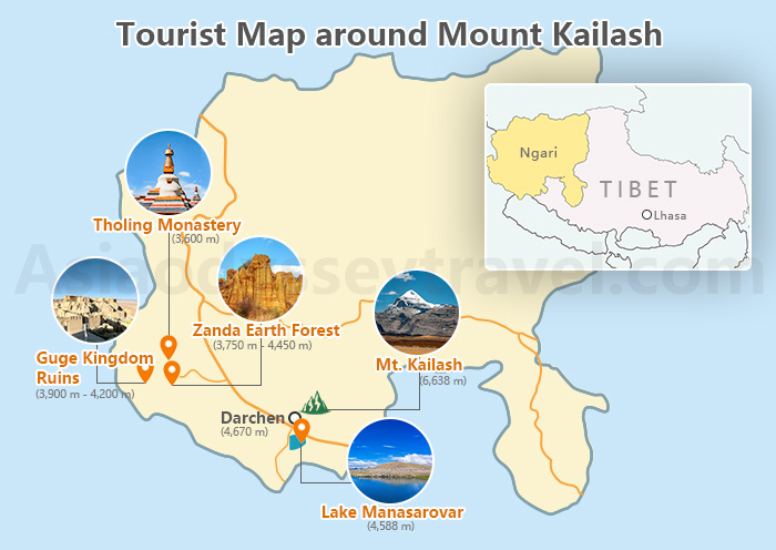
Manasarovar Lake (4,588m):
- When discussing the attractions around Mount Kailash, Manasarovar Lake is a must-visit. Located about 20 kilometers southeast of Mount Kailash at an altitude of 4588 meters, it is revered as the King of Holy Lakes.
- The lake's water is crystal clear and blue, and pilgrims believe that circumambulating and bathing in its waters is the greatest blessing in life. You can even see many practitioners filling water bottles by the lake.
Guge Kingdom (3,900m - 4,200m):
- It is located about 231 kilometers southwest of Mount Kailash. The Guge Kingdom, which ruled the Ngari Prefecture of Xizang from the 9th to the 17th century, mysteriously disappeared, leaving behind a three-story complex of buildings and caves that blend into the surrounding earth.
- From a distance, it resembles a large earthen forest. Up close, the caves reveal exquisite murals, and there are also the famous 'corpse caves' that have gained internet fame.
Zanda Earth Forest (3,750m - 4,450m):
- The Zhada Earth Forest, a natural wonder carved from an ancient lakebed, is located about 127 kilometers north of Mount Kailash.
- This geological marvel offers visitors a unique opportunity to witness the dramatic effects of erosion. With numerous viewpoints, you can capture stunning panoramic views, especially during the golden hours of sunset.
Tholing Monastery (3,600m): Dating back to the 10th century, this temple is the oldest in Tibet's Ngari Prefecture. Nestled northwest of Mount Kailash, approximately 240 kilometers away, it offers a fascinating blend of Indian, Nepalese, and Tibetan architectural influences. The temple's stupa field is a particular highlight.
Map of Mount Kailash Travel: Get to Mount Kailash from Lhasa & Kathmandu
Your journey to Mount Kailash typically starts in either Lhasa, the heart of Tibet (Xizang), China or Kathmandu, Nepal. Explore the Mount Kailash travel map for detailed routes from both cities.
Mount Kailash Map: Lhasa to Mount Kailash
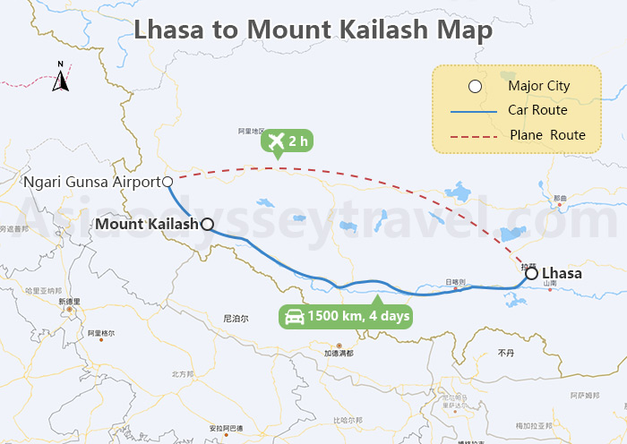
By Air: Approximately 200 kilometers from Mount Kailash lies Ngari Gunsa Airport, which offers direct flights from Lhasa. Lhasa lies east of Mt. Kailash.
You can fly to Lhasa first, then continue to Ngari Prefecture. However, this route is relatively expensive, and high-altitude flights may affect your travel condition. It's still a three-hour overland travel from the airport to our destination.
By Road: The most common and affordable way to reach Mount Kailash is by road trip. Covering a distance of 1500 kilometers, the journey from Lhasa to Mount Kailash typically takes four days.
Route of Road Trip: Lhasa (3,650m) -> Yamdrok Lake (4,441m) -> Shigatse (Over 4,000m) -> Everest Base Camp (5,200m) -> Saga City (Over 4,600m) -> Darchen (4,810m)
Mount Kailash Map: Kathmandu to Mount Kailash
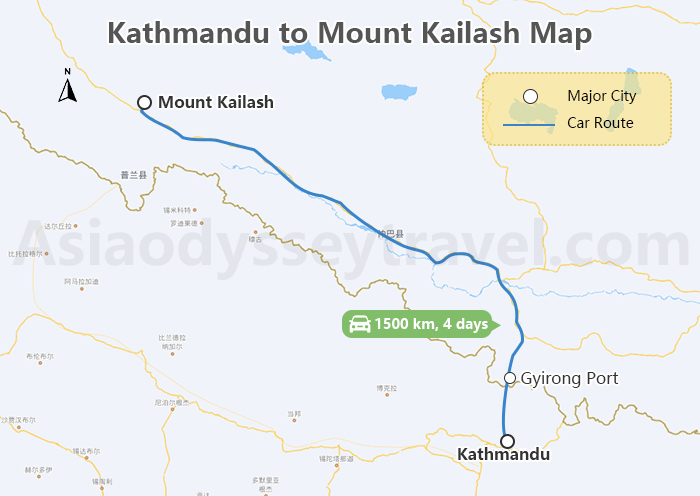
Ngari Gunsa Airport near Mount Kailash doesn't handle international flights. Kathmandu is located to the southwest of Mount Kailash. Starting from Kathmandu, Nepal, you'll need to take a three-day road trip, covering a total of 1500 kilometers, which includes crossing the China-Nepal border.
Route of Road Trip: Kathmandu (1,400m) -> Gyirong Port (1,800m) -> Zhongba (4,583m) -> Darchen (4,810m)
How to Get to Mount Kailash from Lhasa or Nepal
Plan Your Mount Kailash Advanture with Asia Odyssey Travel
If you plan to travel from Lhasa to Mount Kailash, it's recommended to spend three days in Lhasa to acclimatize to the high altitude. Then, start a four-day journey to Darchen, the base camp for Mount Kailash trekking.
Along the way, you'll pass through scenic spots such as Yamdrok Lake, Karola Glacier, Shigatse, Everest Base Camp, and Saga. The next three days will be dedicated to the Kailash Kora, a sacred pilgrimage around Mount Kailash.
On the eleventh day, consider exploring the ancient ruins of the Guge Kingdom in Zanda, and marvel at the Zanda Earth Forest and Tholing Monastery. Finally, spend four days returning to Lhasa overland.
If you wish to extend your adventure and conclude your trip in Kathmandu, Nepal, you can travel directly from Saga to Kathmandu once you've finished the Mount Kailash trekking.