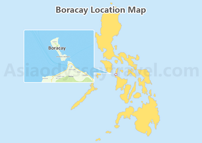
Siargao Philippines Map: Where is Siargao in the Philippines Located?
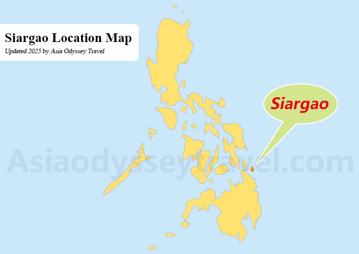
Here's Siargao on the map - it's a teardrop-shaped island in the Philippine Sea, 800 kilometers southeast of Manila.
Look east from Cebu and you'll spot it. The Pacific Ocean is on its east side, the Philippine Sea on the west. Its teardrop shape points southeast, stretching 40 kilometers north to south. The wider northern part narrows down as you move south, lined with coconut trees and surf breaks.
General Luna town sits on the southeastern coast, where most tourists stay. Del Carmen and its mangroves spread across the western shore. The quiet towns of Pilar and Union lie in the south, while the more peaceful Burgos area takes up the northern tip.
The surrounding waters hold several smaller islands. Naked Island, Daku Island, and Guyam Island form a triangle off the eastern coast. Casulian and Poneas islands dot the waters nearby, all within easy reach by boat.
Siargao Tourist Map: Map of Siargao Island with Tourist Spots
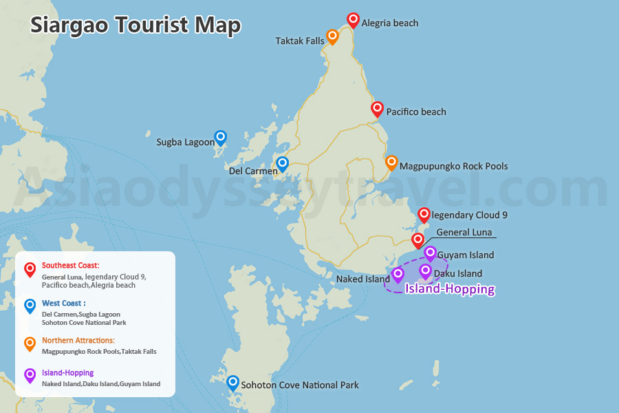
See how close everything is? Siargao mixes world-class surfing and quiet beaches, all a quick boat ride apart. Want secret spots near the famous ones? Want to know best surfing spots in the Philippines, just click?
Southeast Coast: Best for Surfing
Most iconic spots cluster along the southeast coast, radiating from General Luna - the central hub with surf shops and cafes along sandy streets.The legendary Cloud 9 surf break sits here, hosting national surfing competitions with its perfect right-hand reef waves.
Moving east, Pacifico and Alegria beaches offer alternative surf spots, connected by the photogenic "Palm Tree Highway" - one of the most photographed roads in the Philippines.
The West Coast Reveals Different Wonders
Del Carmen: Del Carmen's mangrove reserve covers 8,620 hectares, ranking among Asia's largest.
Sugba Lagoon: Its emerald waters surrounded by limestone cliffs, popular for its diving platform and kayaking spots.
Sohoton Cove National Park: It offers cave exploration and lagoons where you can swim with stingless jellyfish.
Northern Attractions Include
In the north near Pilar, Magpupungko Rock Pools emerge at low tide, forming natural infinity pools above the ocean. These pools, created by ancient coral, fill with clear water against the rocky shore.
Taktak Falls, the island's only waterfall, provides a freshwater swimming option away from the beaches.
Island-Hopping Trio off General Luna
Don't miss the island-hopping trio just offshore:
- Naked Island - A sandbar with 360° ocean views. A pure white sandbar that disappears with high tide.
- Daku Island - Chill in hammocks or feast on beachside kinilaw (ceviche). It's best for picnic-perfect.
- Guyam Island - A tiny circle of sand you can walk around in 5 minutes
Need a customized Philippines tour to See SIARGAO? Just use Asia Odyssey Travel!
Siargao Attractions: 10 Best Things to Do in Siargao (With Itinerary)
Siargao Travel Map: Airport, Pier & More
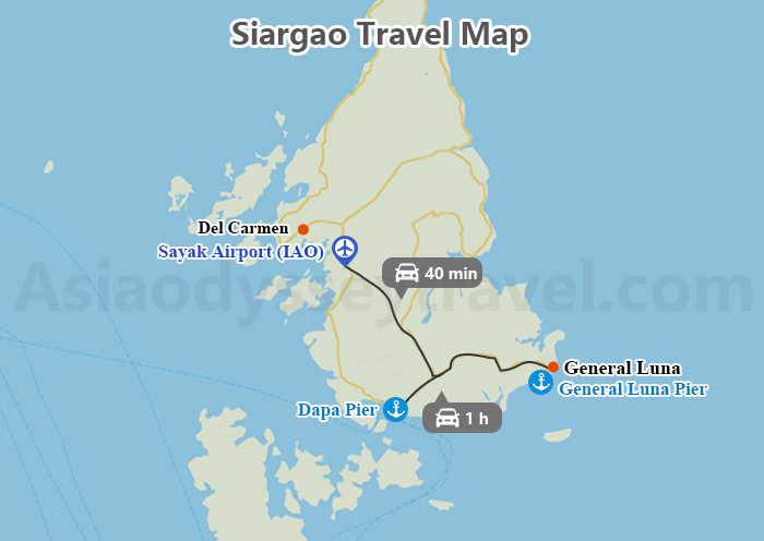
Let's locate Siargao's key transportation hubs on your map. The Sayak Airport (IAO) sits in Del Carmen municipality, about 40 minutes north of General Luna by road. This small airport handles daily flights from Manila (1.5 hours) and Cebu (1 hour).
Two main piers serve island transportation:
- Dapa Pier: The primary ferry terminal (1 hour from GL) with routes to Surigao City (2.5 hours) and Cebu (overnight)
- General Luna Pier: Smaller dock for island-hopping tours
Where to Stay: Siargao Accommdation Areas
For accommodation areas, General Luna in the southeast serves as the main tourist hub. This area holds most hotels, resorts, and guesthouses, ranging from luxury resorts to budget hostels. Cloud 9 area, within General Luna, is particularly popular among surfers.
Pacifico in the northeast offers quieter beachfront stays, popular with experienced surfers. Del Carmen town provides accommodation options closer to the airport and mangroves. Dapa town, near the main port, has some local hotels and guesthouses.
Siargao Transportation Map: How to Transfer to Siargao
Siargao lies in the Philippine Sea, about 800 kilometers southeast of Manila. The island can be reached by air and sea from several major Philippine cities.
Manila to Siargao
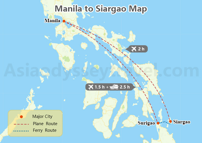
From Manila, travelers have 2 main options. The fastest method is a direct 2-hour flight to Sayak Airport, served by Philippine Airlines and Cebu Pacific.
Alternatively, visitors can take a 1.5-hour flight to Surigao City followed by a 2.5-hour ferry ride to Dapa Port in southern Siargao.
Cebu to Siargao
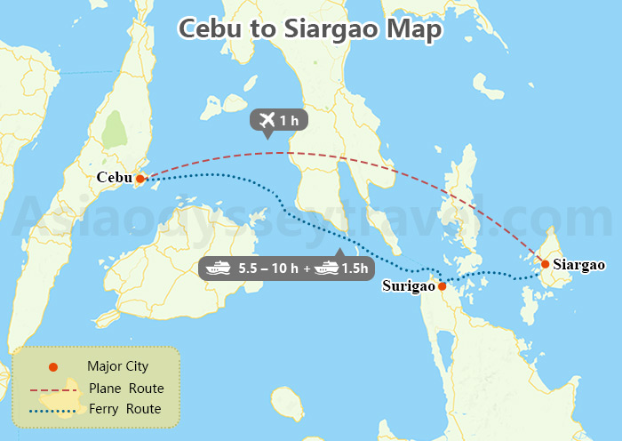
Cebu offers more direct access with 1-hour flights to Sayak Airport. From Cebu, there's no direct ferry to Siargao. But you can take a ferry from Cebu to Surigao City (5.5–10 hours), then hop on another ferry from Surigao to Siargao (1.5 hours).
How to Get to Siargao from Cebu: 2 Best Ways
Transfer Via Cebu & Surigao
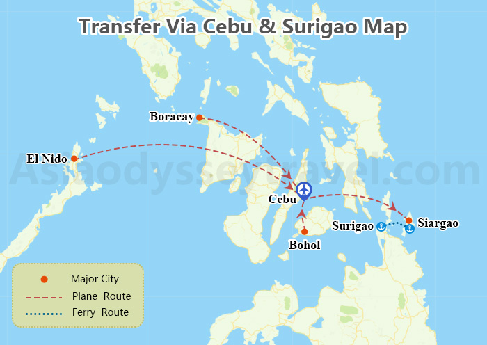
From other Philippine cities like El Nido, Bohol, or Boracay, flying through Cebu is most convenient. Cebu serves as the main transit hub with frequent connections to Siargao.
If you prefer sea travel from any major city, head to Surigao City first. All ferry routes to Siargao run through Surigao Port, connecting to Dapa Port on Siargao. Ferries between Surigao and Siargao operate daily, weather permitting.
Explore Siargao, Philippines with Asia Odyssey Travel
We are Asia Odyssey Travel, a locally owned travel agency with offices in Manila, Puerto Princesa, and Bohol, offering authentic expertise for first-time visitors to the Siargao, Philippines.
✅ 10 Best Philippines Group Tours - Budget-friendly adventures, small group;
✅ 40+ Private Tours - Customized adventures to secret beaches
Your Siargao Guide: Cebu to Siargao, Things to Do, Siargao Map
Let's chase waves at Cloud 9 and discover Siargao's hidden treasures together!
If you have any questions about this article, please contact us by submitting the following form and we'll immediately get back to you.